


Tracking better weather in Houston after Saturday’s storms and ahead of our next front
Watching multiple cold fronts swing this week
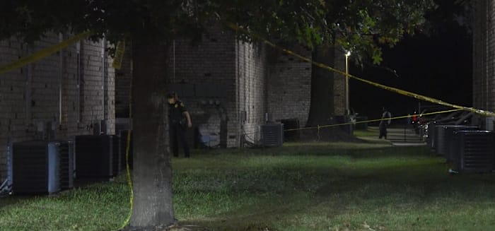
Happening NOW: We’ve been watching and tracking several serious accidents on our roadways this morning. Before yesterday’s storm, Houston didn’t have measurable rain since September 24. This creates oil, dirt, and debris on our roadways. This slippery buildup drastically reduces tire grip, creating dangerous driving conditions. Drive with utmost caution, slow down, and maintain a safe distance from other vehicles to avoid accidents.
Today starts mostly cloudy, with the sun shining through by midafternoon and a high in the lower 80s. With the lower humidity, it’s a great day to enjoy our seasonable temperatures. 
The Next Cold Front:
We’re tracking another front that’s going to push us right into fall with morning lows in the 50s and our highs in the upper 70s which means you’ll want to start adding layers to your Halloween costumes. 

Elevated Fire Risk:
Burn bans are remain in effect across the area with only a few counties left without bans. While the introduction of some rain chances this week are good in terms of bringing some rain chances, however, we would need a few weeks in a row of consistent fronts with lots of rain before they would likely take off some of the burn bans. 
- Avoid spark-causing activities, as fires can flare up fast.
- Never leave a fire burning unattended or without purpose.
- Secure tow chains to prevent dragging and sparking.
- Don’t drive or park over tall grass.
- Avoid tossing lit cigarettes onto the ground.
Your extended forecast:
Our strongest cold front this season moves through next Tuesday bringing temperatures in the 70s with sunny skies and lows in the 50s. Just in time for Halloween!
Click 2 Pins
If you notice interesting weather in your neighborhood, share your photos and videos with KPRC 2 at Click2Pins!