


Houston will see several cold fronts over the next week
Watching multiple cold fronts swing this week

Tonight’s Forecast:
We are muggy and buggy this evening. Humid air does not cool as efficiently as dry air, which is why we will start off our Tuesday 15-20 degrees warmer than Monday morning.
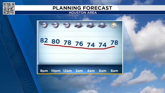
Tuesday’s Forecast:
Another front approaches Tuesday, this will bring a low chance for showers but another drop in humidity once the front clears. We’ll even notice temperatures dropping from the 90s to the mid-80s from Tuesday to Wednesday. 
Your extended forecast:
Our first cold front this week arrives Tuesday. Our subsequent cold front comes at the end of next week to keep our highs into the mid-80s. Our weekend front will also bring our next substantial chance for rainfall with the whole area having the potential to see over an inch of needed rainfall. 
Elevated Fire Risk:
Burn bans are remain in effect across the area with only a few counties left without bans.
While the introduction of some rain chances this week are good in terms of bringing some rain chances, however, we would need a few weeks in a row of consistent fronts with lots of rain before they would likely take off some of the burn bans. 
- Avoid spark-causing activities, as fires can flare up fast.
- Never leave a fire burning unattended or without purpose.
- Secure tow chains to prevent dragging and sparking.
- Don’t drive or park over tall grass.
- Avoid tossing lit cigarettes onto the ground.
Click 2 Pins
If you notice interesting weather in your neighborhood, share your photos and videos with KPRC 2 at Click2Pins!