


Houston’s storm timeline this weekend
A third straight week of bone dry weather may get a little relief from a weekend cool front

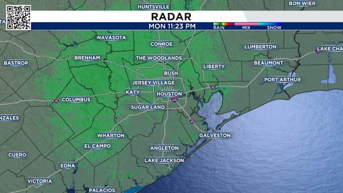
For the first time in weeks we are tracking scattered showers across SE Texas! These showers shouldn’t be causing any issues, mainly just sprinkles! Check out our current radar below.
Tonight’s Forecast:
It really feels like summer! We are humid and warm with quick downpours moving in from the coast. Most of these showers will be totally out of here by 6PM, which means a great Friday night! There should be no concerns for Friday night football games. 
Saturday’s Storm Threat:
We have a storm threat across Houston this weekend, with a severe weather threat NE of Houston. The primary concern is the threat for damaging winds. 
We’ll start off the day with scattered light rain showers by the coast. Shouldn’t cause any problems. 
By the afternoon these will drift further inland and it’s possible we can start seeing scattered thunderstorms by 2PM. This first round of storms are pre-frontal, they are diurnal thunderstorms that will blossom during the heat of the day. 
By 5PM we have a chance of some stronger storms with frequent lightning strikes and heavy downpours, especially northeast of Houston. Areas to the Northeast also have a damaging wind threat. 
By 9PM we’ll be tracking our actual cold front that will be bringing storms from the northwest to the southeast. Huntsville, Conroe, Brenham, Tomball, you’ll see these storms first. 
This line will likely push through the Houston area around 11PM, and they may be quite noisy with lightning and strong winds. Put the dogs in their thunder jackets before bed. 
While the cool front won’t bring a convincing push of cooler weather, it will bring an early alarm clock on Sunday as the line of storms comes through! 
The front will keep progressing southeast and exit off the coast by 2AM. We will then be dry for all of Sunday. 
Now remember, forecasting is not a perfect science, the cold front could speed up or slow down, they usually they speed up, so it’s possible the times could be a little adjusted.
Elevated Fire Risk:
Despite the increase in humidity and rain chances, we continue to monitor fire dangers across SE Texas. Burn bans are increasing across the area with only a few counties holding out. 
- Avoid spark-causing activities, as fires can flare up fast.
- Never leave a fire burning unattended or without purpose.
- Secure tow chains to prevent dragging and sparking.
- Don’t drive or park over tall grass.
- Avoid tossing lit cigarettes onto the ground.
We will likely see more counties added to the list through the next few weeks, especially if we stay in this hot and dry pattern, which appears that we will.
Your extended forecast:
Afternoons will still stay warm and we’ll see more humidity by the end of the week as a front will brings showers and thunderstorms Friday and Saturday. And it looks like our next fall morning looks to be at the end of the 10 day forecast.
If you notice interesting weather in your neighborhood, share your photos and videos with KPRC 2 at Click2Pins!


