


Coolest morning since early May on Monday before humidity returns ahead of next cold front
Watching multiple cold fronts swing this week
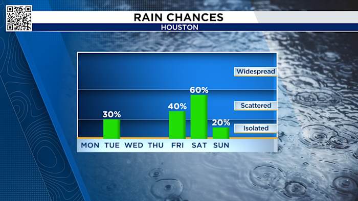
Monday morning felt the effects of the weekend cool front, dropping temps into the 50s and 60s. The morning low dropped below 60 degrees, the first time a low temperature reached 59 degrees since May 4th.
Winds will turn more southerly throughout the day, this will help bring back a Gulf moisture into SE Texas, so expect a rise in humidity once again. 
Elevated Fire Risk:
Burn bans are remain in effect across the area with only a few counties left without bans.
While the introduction of some rain chances this week are good in terms of bringing some rain chances, however, we would need a few weeks in a row of consistent fronts with lots of rain before they would likely take off some of the burn bans. 
- Avoid spark-causing activities, as fires can flare up fast.
- Never leave a fire burning unattended or without purpose.
- Secure tow chains to prevent dragging and sparking.
- Don’t drive or park over tall grass.
- Avoid tossing lit cigarettes onto the ground.
Tuesday’s Forecast:
Another front approaches Tuesday, this will bring a low chance for showers but another drop in humidity once the front clears. We’ll even notice temperatures dropping from the 90s to the mid-80s from Tuesday to Wednesday. 

Your extended forecast:
We are also tracking a cold front Tuesday that will shift our winds. Our final cold front comes at the end of next week to drop our highs into the mid-80s.
If you notice interesting weather in your neighborhood, share your photos and videos with KPRC 2 at Click2Pins!