


Houston braces for strong cold front bringing heavy rain and flood threat Saturday
Watching multiple cold fronts swing this week
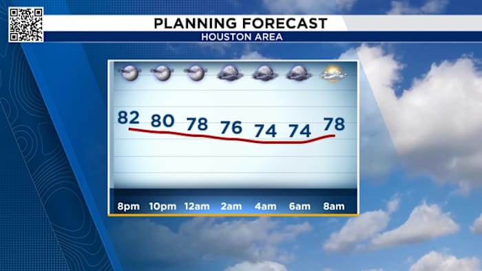
Hour By Hour Look:
Friday’s Forecast:
Friday will be a good day to check your yard/land for anything that could blow away as some of the stronger storms will move in early Saturday morning. We’ll stay warm and breezy with highs generally in the mid 80s and some spotty downpours. 
Stormy Saturday Forecast:
The next front looks to plow across Texas on Saturday and it will bring a threat for some heavy rain and storms for most of SE Texas. 

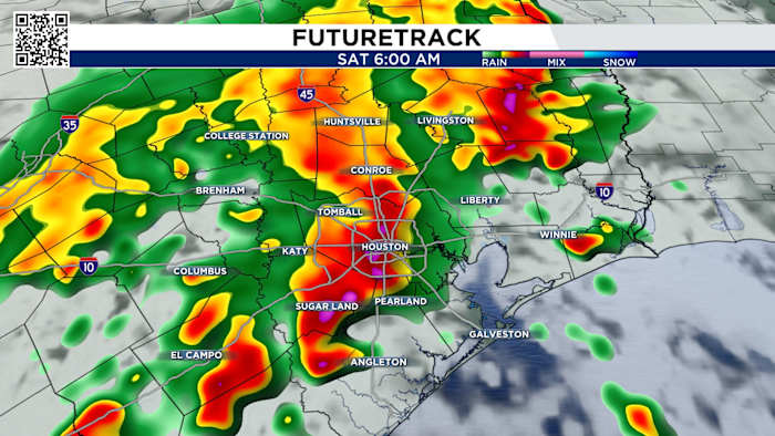
Storm Timing:
The storms will come generally in two batches. Expect the first wave early Saturday morning with strong winds, heavy rain pushing through around 4-7am.
The first round moves through EARLY Saturday morning. This will reach the Brazos Valley by 3AM and work its way east.
The storms will be reaching Houston around 6AM in the morning. These storms might be strong to severe, with street flooding likely, so don’t plan sunrise activities
This first line will exit the coast by 8AM, and Houston will be mostly dry by 10AM. 
Through the majority of the day, we’re dry and windy. Now, I would not be surprised if we see a few isolated pop-up storms.
Ok now our second round of storms comes with the cold front and it looks to be speeding up. Everything is still expected after sunset, with storms rolling in from the northwest reaching the Brazos Valley as early as 7-8PM.
These storms will reach Houston anywhere from 9PM-11PM. Thankfully this front is not expected to stall, so if you have late night plans Saturday you might have to stay a little later than planned until the storms push through.
These storms will race to the coast by 1AM. This will end the severe and flood threat for SE Texas this weekend. 
In fact, because we have been so dry for over a month, if some areas get too much rain too quickly, that’s a good recipe for possible street flooding in some areas. 
That’s why we’re under a 2 out of 4 threat for flash flooding on Saturday. 
And remember, since we do have a small tornado threat, you’ll want to make sure your phone’s volume is up and alerts are ON — that way you’ll be woken up if a warning is issued while you’re asleep.
Elevated Fire Risk:
Burn bans are remain in effect across the area with only a few counties left without bans. While the introduction of some rain chances this week are good in terms of bringing some rain chances, however, we would need a few weeks in a row of consistent fronts with lots of rain before they would likely take off some of the burn bans. 
- Avoid spark-causing activities, as fires can flare up fast.
- Never leave a fire burning unattended or without purpose.
- Secure tow chains to prevent dragging and sparking.
- Don’t drive or park over tall grass.
- Avoid tossing lit cigarettes onto the ground.
Your extended forecast:
Our strongest cold front this season moves through next Tuesday bringing temperatures in the 70s with sunny skies and lows in the 50s. Just in time for Halloween!
Click 2 Pins
If you notice interesting weather in your neighborhood, share your photos and videos with KPRC 2 at Click2Pins!


