


Another fall day? Yes, please Houston.
Our next tropical system forms this week in the Atlantic Ocean
Tonight’s Forecast:
This morning was prime time for pumpkin patch adventures and sipping on PSLs, with chilly lows dipping into the 60s. Tonight’s low will stay in the 70s and by morning - we’ll be in the upper 60s.
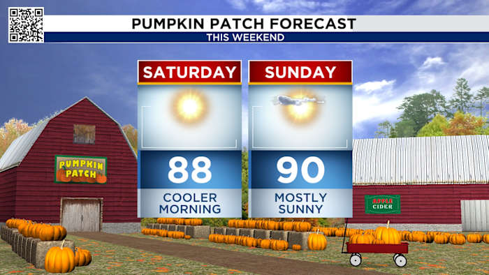
Sunday’s Forecast: If you loved yesterday’s gorgeous weather, you’re in for a treat—Mother Nature’s doubling down today! We’ll wake up to crisp mid-60s mornings, warming to the low 80s by afternoon, perfect for soaking up the sun. However, stay alert: an air quality advisory is in effect, with high ragweed pollen levels and heightened fire risk, particularly along the I-45 and US-59/69 corridors in the north.
An air quality alert is in effect for Houston, Galveston, and Brazoria today, with elevated fire danger continuing through tonight. Skip the bonfires, especially near the I-45 corridor, where fire risk remains high.
Fire Danger Warning:
Dry, warm weather boosts fire risk through tonight with another fire risk tomorrow too. So even with that fall crispness, steer clear of bonfires. 
- Avoid spark-causing activities, as fires can flare up fast.
- Never leave a fire burning unattended or without purpose.
- Secure tow chains to prevent dragging and sparking.
- Don’t drive or park over tall grass.
- Avoid tossing lit cigarettes onto the ground.
Tracking the tropics:
Tropical Update:
We’re tracking a tropical wave a few hundred miles away from southwest of Cabo Verde Islands. We’ll watch for the chance for tropical development next week while moving west-northwestward at 15-20 mph across the central tropical Atlantic.
Your extended forecast:
You’ll be waking up in the 60s with highs in the mid-80s this weekend, so enjoy it while it lasts because by next week, our lows will pop back up in the 70s with highs above average in the 90s.
If you notice interesting weather in your neighborhood, share your photos and videos with KPRC 2 at Click2Pins!